Laos by hand-drawn map
Going round The Loop in Thakhek
October-November 2010
Little known, off-the-beaten track, undiscovered, under the radar. Sure, they’re lazy phrases and guidebook cliches, but I can’t resist. They promise an escape from backpacker circuits and well-trodden tourist trails. They have the allure of unexpected, alternative adventures. They offer to share a glimpse of somewhere special and, when the opportunity to explore so-called uncharted territory comes with a hand-drawn map, it just adds to the sense of secrecy.
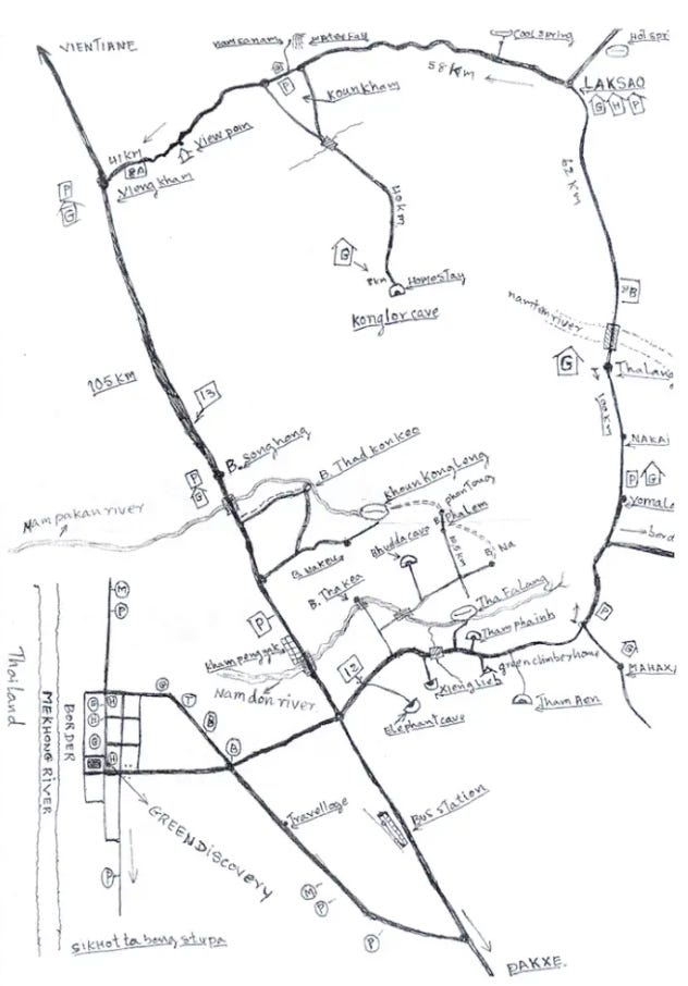
That’s how, while exploring Laos in 2010, we found ourselves scootering towards King Lor clutching a piece of photocopied paper. A small section of our 2007 edition of the Lonely Planet introduced us to ‘The Loop’, describing it as ‘an off-the-beaten-track circuit through some of the more remote parts of Khammun and Bolikhamsai Provinces’. It outlines a couple of main sights and stops along the way, and suggests checking out the travellers' book at Thakhek Travel Lodge for the latest information. Of course, this was before smartphones (I used a battered Nokia to text my parents once every few days) and widespread internet access, so you relied on the anecdotes of the other adventurers you met along the way. And on hand-drawn maps. You really relied on hand-drawn maps. Thankfully, we found Mr Ku – who ran a scooter rental service next door to the lodge – was more than happy to oblige.
And so began our four-night odyssey, tackling the loop anti-clockwise, during which we wrestled the bike through rivers and across broken bridges, relied on willing strangers to help us repair punctures, consumed countless side-of-the-road bowls of noodles and repeated the phrase ‘let’s get to town before sunset’ with increasing urgency as the temperature dropped and the light faded at the end of each day. And by town, we’re talking a handful of home-stays, a food stand with a few plastic chairs arranged out front. The kind of place where you go to bed at 8pm because there’s another power cut and you’ve had your one beer for the evening and there’s nothing else to do.
Looking back at the journal I had with me at the time, I discover Mr Ku’s squiggly lines and spidery annotations had inspired me to draw my own map where I recorded our progress.
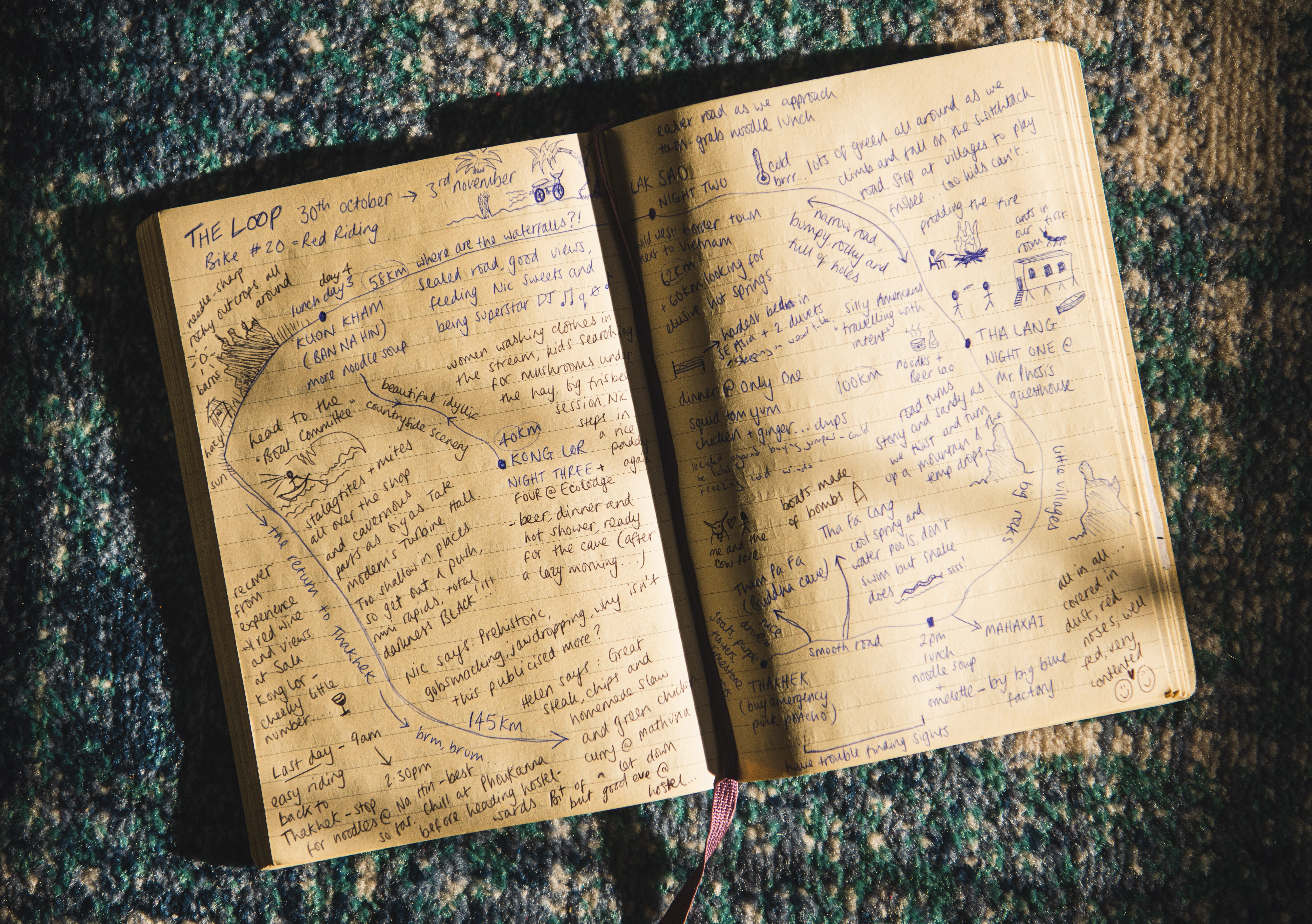
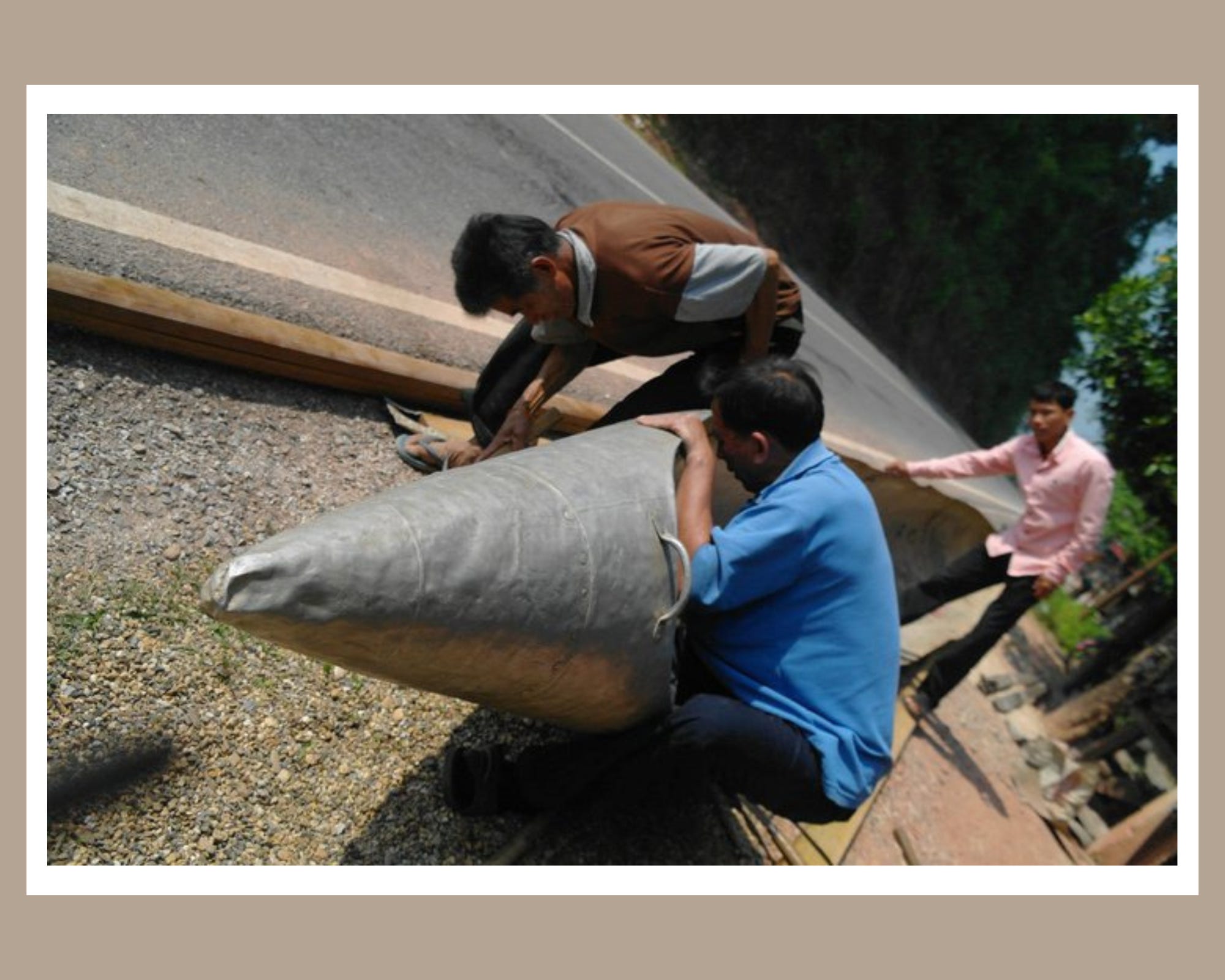
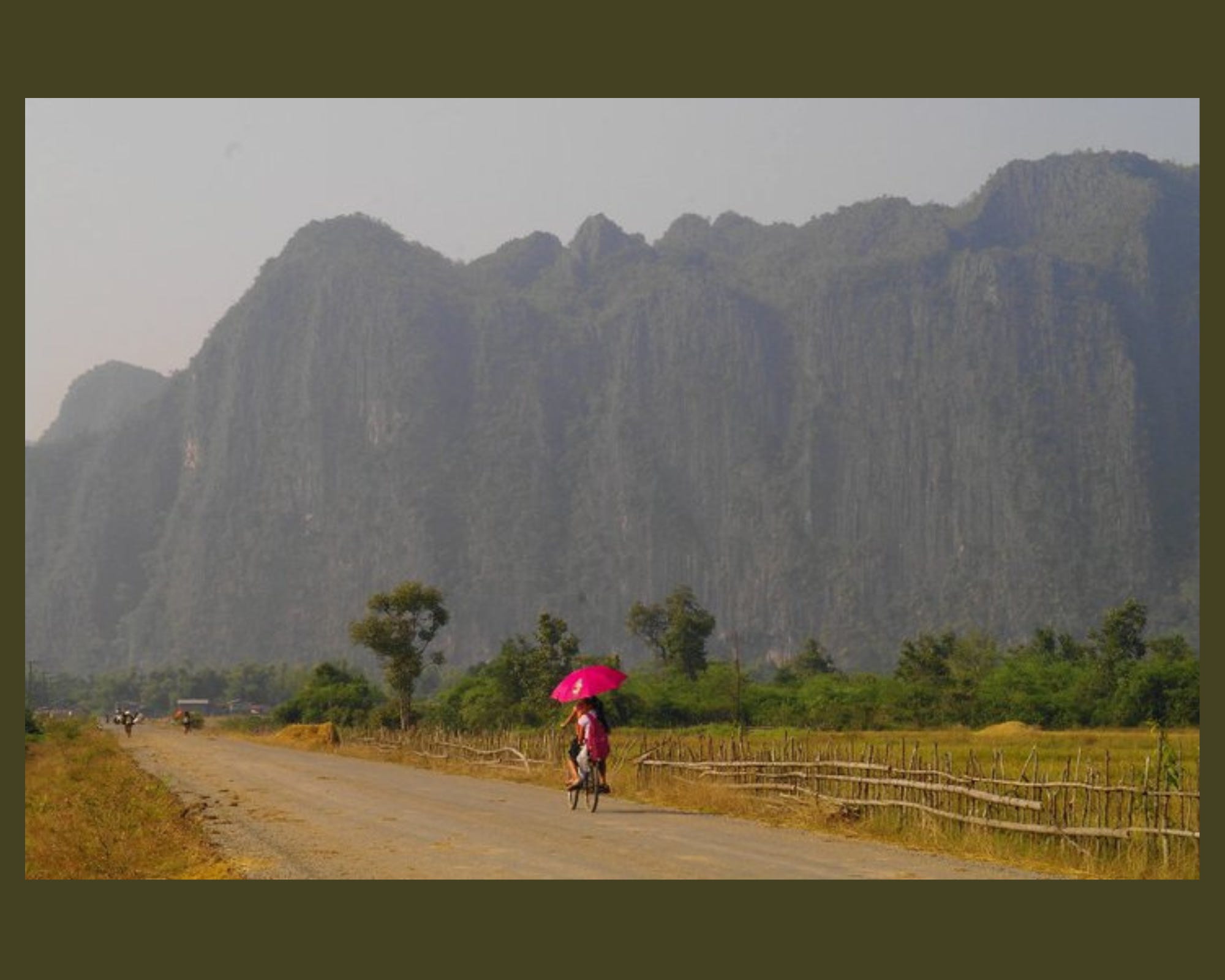
I write that I buy an emergency pink poncho before leaving Thakhek and that we follow a smooth road out of town past goats, purple flowers and limestone karsts. There’s a picture of a snake beneath the words Tha Fa Lang and I instantly remember arriving at this stunning natural swimming pool and debating whether we had time for a swim, deciding against it and then seeing a huge black snake charging through the water – its head rising from the water cobra-style. Horrifying. There’s a note that silver bomb shells are being beaten and bent into the shape of shiny canoes. We also see shrapnel forming fences around many homes. We stop for omelettes just before reaching Mahaxai. The words ‘little villages, big rocks’ lead up the twist and turns of a mountain road towards our overnight stop at a home-stay in Tha Lang, where there are ants in our room and a roaring fire outside, besides which we share a bottle of Beer Laos.
Day two follows a ‘narrow road, rocky and full of holes’. We stop to introduce a small class of children to our frisbee (it drops into a well but the oldest boy somehow retrieves it, dries it on his shirt, hands it back to us). We drive an extra 60km looking for ‘elusive hot springs’. We spend the night in Lak Sao – a ‘wild west border town next to Vietnam’ – where we encounter the ‘hardest bed in SE Asia’ – my husband is so disgruntled he adds his own notation: ‘like sleeping on a wooden table’.
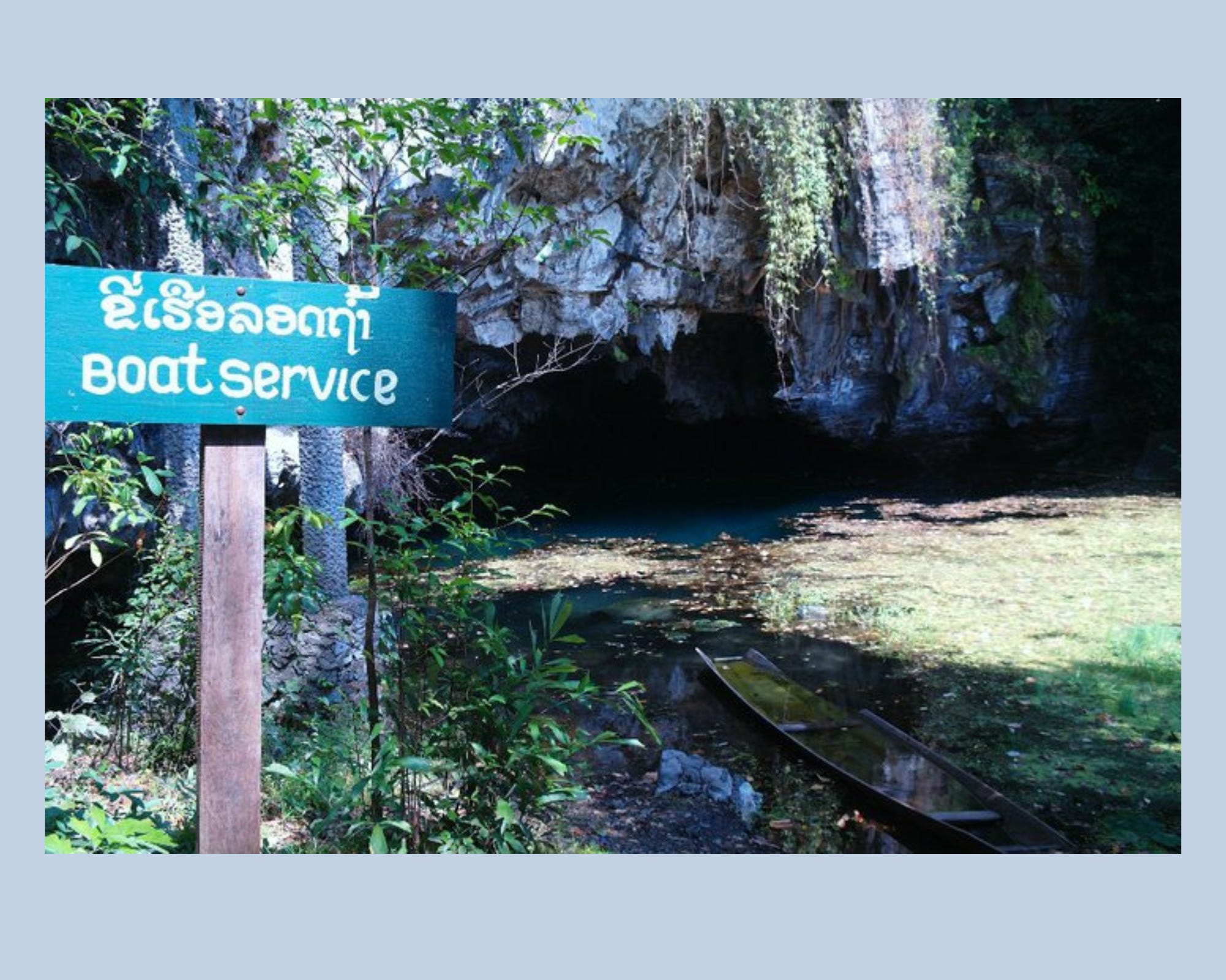
The next morning, it seems spirits were high as we followed sealed roads towards lunch in Kuon Kham before a beautiful 40km journey along a dusty unsealed road to Kong Lor and its famous underground waterways. We pass women washing clothes in a stream and two girls searching for mushrooms amid piles of hay, in the evening, we blow up balloons and kick them around with the local kids as the sun sinks below the craggy peaks, flooding the fields with a golden haze.


We spend the following day floating through the caves (having bailed out water from our boat), head torches illuminating stalagmites and stalactites. Some areas are as ‘big as Tate Modern’s Turbine Hall’, while in other places the water is so shallow and the tunnels so narrow we have to get out and walk. When we turn off our lights, I write that it’s ‘total darkness, black’ (with four exclamation marks).
Later that day, we drink red wine at Sala Kong Lor Lodge and I put the finishing touches to our visual itinerary, gazing out at the beautiful countryside, before collapsing into bed at the nearby Eco Lodge, which judging by recent reviews, is just as good as I remember.
But of course, things change. Where people venture, others will follow. When we tackled the loop there wasn’t the option to take a tour all the way there – a bus would drop those not arriving by scooter in Kuon Kham – although I understand the road is now sealed making travel much easier. Meaning more people can enjoy Kong Lor’s off-the-beaten-track beauty. And the local economy (hopefully) benefits as the number of visitors to the area increases.
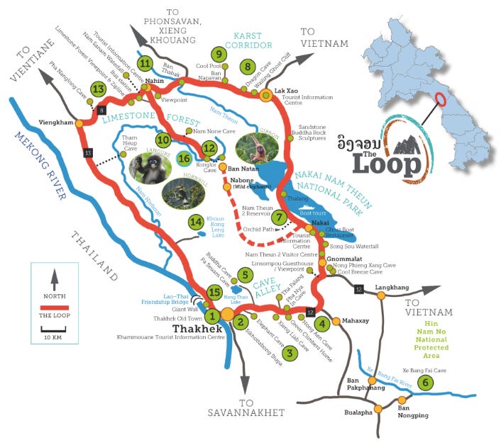
Which brings us today, when a quick Google leads to an interactive map of the Thakhek Loop, where pictures pop up as you scroll over each stop, spoiling the surprise. Of course, there are advantages to being constantly connected, a few clicks away from ratings and reviews and recommendations. But – thanks to our hand-drawn map – our experience of the loop revolved around vague directions, dead ends, searching for signposts, guessing how far till our next stop and wondering where we’d stay when we got there. And that’s where the real under-the-radar rewards are.